
Accurate. Reliable. Real‑Time Field Insights.
At CADSYSTECH LLC, we deliver end‑to‑end Field Data Collection solutions that help organizations capture high‑quality geospatial and asset information directly from the field. Our expert team combines advanced mobile data‑capture technologies, GPS/GNSS tools, and industry‑standard workflows to ensure your field data is precise, consistent, and ready for downstream processing.
Our Field Data Collection Capabilities
Our field data collection capabilities combine high‑precision tools and modern GIS technologies to deliver accurate, reliable, and engineering‑grade asset information. We capture detailed attribute and location data for utilities, infrastructure, land parcels, telecom networks, pipelines, and more—using advanced mobile GIS applications such as Collector, Survey123, Field Maps, QField, and Trimble tools to ensure efficient, error‑free surveys. With sub‑meter and centimeter‑level GNSS equipment, our teams produce highly accurate ground measurements that support mapping, planning, and compliance workflows. We also perform on‑site utility and infrastructure verification to confirm asset conditions and identify deviations for construction, QA/QC, and maintenance needs. For large or hard‑to‑access areas, our optional drone‑assisted workflows further enhance spatial accuracy through high‑resolution imagery and photogrammetry.
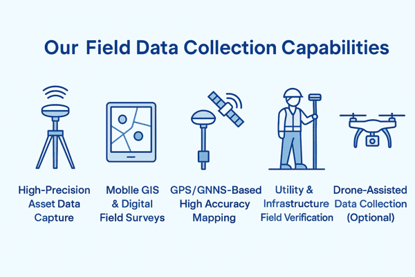
High-Precision Asset Data Capture
We collect detailed attribute and location data for utilities, infrastructure, land parcels, telecom assets, pipelines, and more—ensuring accuracy that supports engineering, GIS analytics, and compliance needs.
Mobile GIS & Digital Field Surveys
Our field teams use modern mobile applications (Collector, Survey123, Field Maps, QField, Trimble tools, etc.) for efficient and error-free data capture.
GPS/GNSS-Based High Accuracy Mapping
We employ sub-meter and centimeter‑level GNSS receivers to capture accurate ground data for mapping and engineering workflows.
Utility & Infrastructure Field Verification
We verify existing assets, on-ground conditions, and deviations to support planning, construction, and QA/QC processes.
Drone-Assisted Data Collection (Optional)
For large or inaccessible sites, we integrate drone imagery and photogrammetry into field data workflows for better spatial accuracy.
Key Features of Our Service
- Standardized data collection templates for consistent reporting
- Real-time data validation to reduce errors
- Offline data capture for remote locations
- Integration-ready outputs (GIS, CAD, BIM, databases)
- Configurable workflows based on project requirements
- Secure data handling through cloud-based environments
Our Workflow
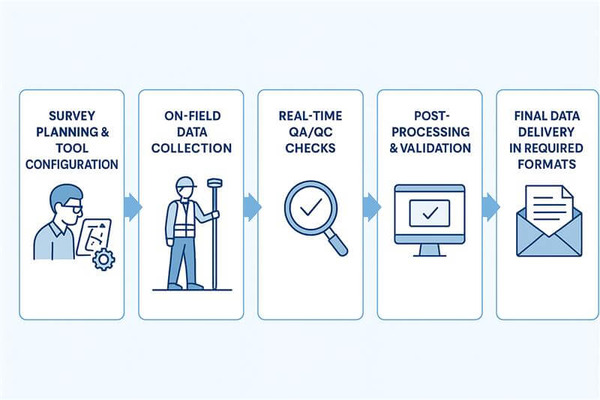
- Project Assessment & Requirement Study
- Survey Planning & Tool Configuration
- On-Field Data Collection
- Real-Time QA/QC Checks
- Post-Processing & Validation
- Final Data Delivery in Required Formats
Industries We Support
- Utilities & Energy
- Telecommunications
- Transportation
- Municipal & Government Agencies
- Environmental & Land Management
Why Choose CADSYSTECH LLC?
- Experienced field survey professionals
- Proven methodologies for accurate data capture
- Technology-driven, scalable workflows
- Seamless integration with GIS & CAD platforms
- End-to-end support from field to final deliverables